Interview with SeaBee’s Sindre Molværsmyr
Charlotte Garmann-Johnsen | March 14th, 2025 | Our Work Related
Interview with Sindre Molværsmyr, biologist and technical responsible at NINA in Bergen

Sindre giving a presentation on SeaBee.
Q: How much do you work on or with SeaBee?
Working with mapping, camera and drone monitoring, tagging and GPS tracking of seabirds. Working with SeaBee is a significant part and a lot through SEAPOP. SEAPOP has had field campaigns with mapping, taking pictures with drones, uploading data afterwards to SeaBee. without Seabee and if NINA were to use drones for mapping campaigns, we would have to have built it ourselves and it costs a lot of money and it would have been difficult to convince the boss that we should use drones, because no one had shown that it was possible, that this would be very expensive. Just data storage costs a lot. If we were to set up Seabee internally at NINA it would cost a few million a year.
Q: Can you comment on how much the use of drones has impacted the cO2 footprint of your work?
We have not stopped the old monitoring methods, we still go ashore, because there are many things we still cannot do without going ashore to the colonies. For example, ringing chicks, catching adults on nests to put on GPS, etc.
Q: How is it to count birds using drones?
I must specify that not all species can be observed with drones, we do not actually map seabirds, we map specific species. We do not map great cormorants and eiders in this way. These are the ones you lose by switching to drones, because when you go ashore you can look under all the rocks and see how many great cormorants there are, while with drones you can’t see anyone. But for that we have some races that we run in parallel.

Line of sight vs. Drone observations in SEAPOP seabird counting missions. Source: Sindre Molværsmyr
The advantages of using drones are two things in particular:
- The precision goes up a lot for species that are visible. The numbers are almost not comparable because the precision is so much higher. With drones you can observe again and again several times so that you get changes in the colony, you know what is happening with all the nests throughout the season, which you can get by going ashore and walking around there, but it is much more difficult and more disruptive
- It is so much easier to find personnel who can be trained to fly a drone over a colony than to train personnel to recognize gull nests based on the egg and how the twigs are located and have the knowledge to go ashore and do a proper job. It requires some experience because it depends on which ways the gull nests are located and that you remember to look in all of them. It is not easy and not something you can just learn in an afternoon. Flying a drone is much more repeatable, almost anyone can actually do it.
NINA has around 500 seabird mapping missions per year. Right now there are 1411 seabird flights on SeaBee, it is the first that exists in Norway. I have calculated a little about the CO2 footprint last year, and ignored production in China, but we work by boat and went from the Swedish coast to Stavanger by boat and used 70 kg of CO2 from diesel, you can drive a Cessna for 10 hours with that, we did that before. But the data quality of what we collect will be much better. The logistics details will be quite similar, because you have to use a boat anyway. Drone mapping has quite comparable costs with small plane trips, that’s because using a boat is expensive.

Viewing Seagull colonies from a drone. Source: Sindre Molværsmyr

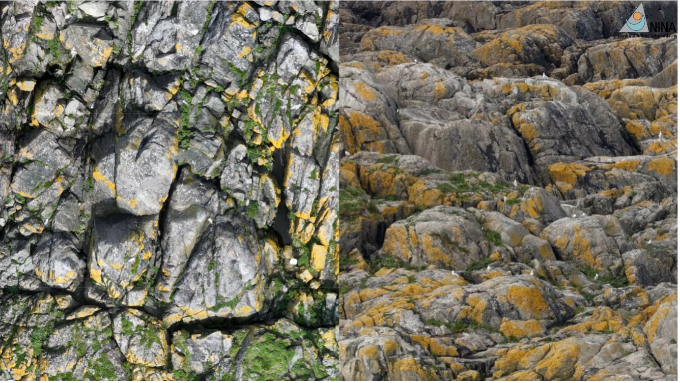
An example of the higher resolution available for bird monitoring with drone imagery. Source: Sindre Molværsmyr

The result of seabird mapping, a seabird population map. Source: Sindre Molværsmyr

SeaBee as a platform for data storage and sharing includes AI-based image processing and auto-generated products such as this seabird population map.
SEAPOP collaborates with SeaBee, and other projects such as Birdlife have both used and uploaded data to SeaBee, tern monitoring, for their master’s thesis. There is an opportunity for more collaboration with more open-sea measurements.
Q: So what are the advantages of using drones for monitoring?
The advantage of using SeaBee is that you come into an established infrastructure that has all the solutions, so that organizations don’t have to set it up internally themselves. It must become easier to get in. And machine learning can identify seabirds, seals, and habitats now, but it could also be used for flowers, rocks, pastures, reindeer herding, anything if SeaBee gets funding for development. If SeaBee had been open to people/anyone to upload their own data and train their own models, it could have been used on a global scale. SeaBee as it is now might have worked in the UK and the Netherlands.
To learn more about Sindres work at SeaBee, watch his talk on YouTube here!