SeaBee at the MPA in MSP Conference in Bodø
Trygve Heide | July 12th, 2025 | Stories
SeaBee Showcases Cutting-Edge Drone and AI Tools for MPA Monitoring at Bodø Conference
At this year’s Marine Protected Areas in Marine Spatial Planning (MPA in MSP) conference in Bodø, SeaBee made waves with a presentation of how drones and artificial intelligence are transforming marine habitat monitoring. Representing the Norwegian Institute for Water Research (NIVA), researcher Charles Lavin presented a poster unveiling how SeaBee’s innovative technologies are reshaping the way we map and manage coastal ecosystems.

From Manual Surveys to Machine Learning
Traditional marine habitat monitoring has long relied on divers, boats, and labor-intensive fieldwork. But as Lavin and his collaborators from NIVA, SpectroFly, and the Norwegian Computing Center showcased, the future is airborne and algorithmic.
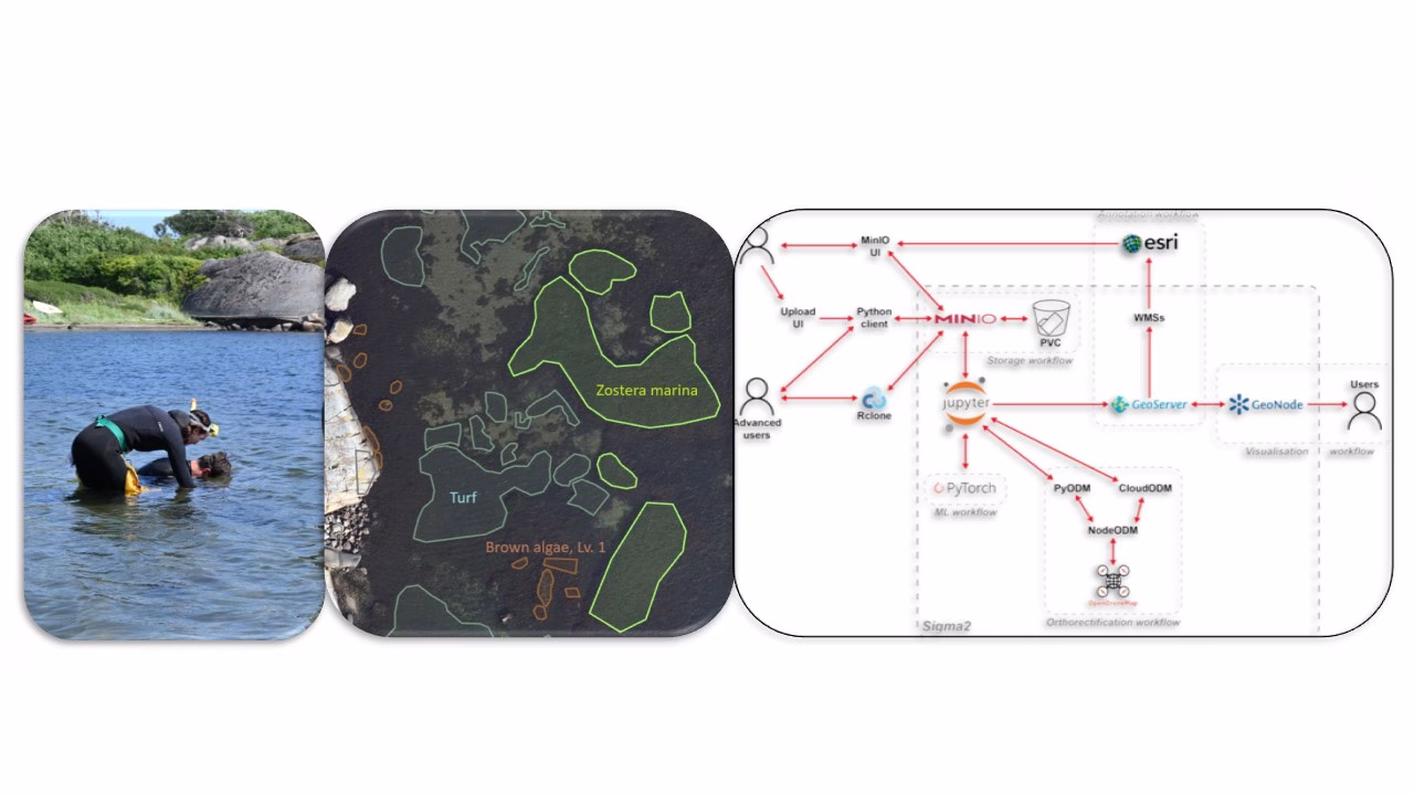
Using unoccupied aerial vehicles (UAVs) equipped with optical sensors and LiDAR, the team demonstrated how high-resolution data can be collected and processed to classify and quantify key marine habitats, such as eelgrass (Zostera marina) and kelp (Laminaria hyperborea), with unprecedented accuracy and efficiency.

LiDAR: Seeing Beneath the Surface
One of the highlights of the poster was a case study using a medium-sized drone carrying a 4.1 kg LiDAR sensor. Flying at 50 meters above eelgrass beds in Norway, the drone captured nearly 900,000 data points across a 1.3-hectare area, achieving a remarkable 70 points per square meter.

Using Random Forest classification, the team distinguished between vegetation and seafloor, leveraging backscatter intensity as a key variable. From this, they constructed detailed Digital Surface Models (DSM) and Digital Terrain Models (DTM), enabling them to calculate eelgrass canopy height, habitat volume, biomass, and even carbon content—a crucial metric for blue carbon assessments.
Results at a glance:
- Eelgrass area: 4,909 m²
- Habitat volume: 861 m³
- Above-ground biomass: 1,146 kg (wet weight)
- Carbon content: 87 kg

AI-Powered Habitat Mapping
In another example, the team deployed drones with RGB and multispectral sensors to map a small Norwegian bay. After geo-referencing the imagery, they trained machine learning models—including UNet, Faster R-CNN, and DDCM—on ground-truth data to classify habitat types pixel by pixel.
These models, integrated into the SeaBee data analysis pipeline, not only deliver high-resolution habitat maps but also provide confidence scores for each classification, helping researchers detect anomalies and out-of-distribution data.

A Platform for the Future of Coastal Monitoring
As marine spatial planning becomes increasingly vital in the face of climate change and biodiversity loss, tools like SeaBee are proving essential. Lavin’s presentation in Bodø underscored how science, technology, and collaboration can come together to protect our oceans, one pixel or one point cloud at a time.