Stories Library
Stories

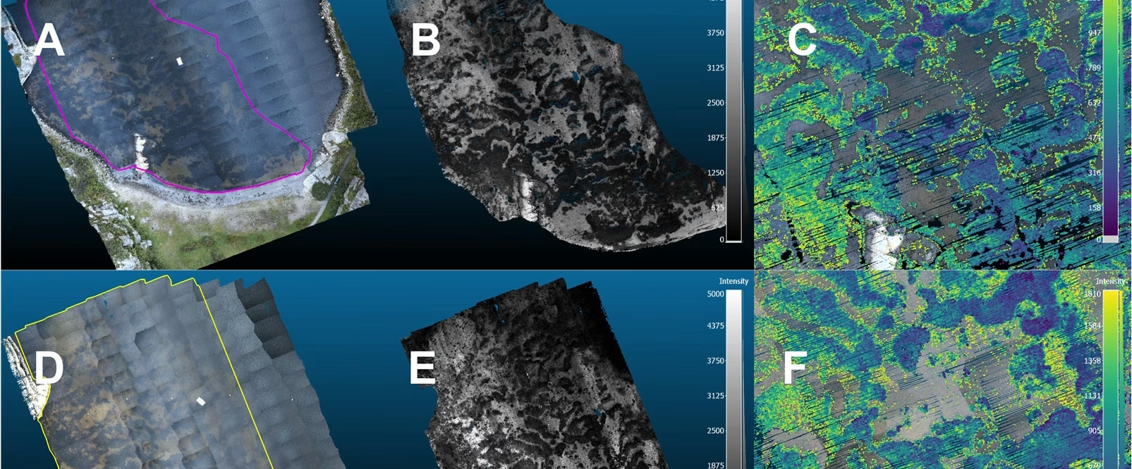
Seeing seagrass in 3D
A new SeaBee study published in Remote Sensing shows, for the first time, how a flying drone carrying a green ...
SeaBee scales up with LUMI
SeaBee partners with Europe's most powerful computer to crack its data bottleneck SeaBee has engaged with the LUMI AI Factory as one ...
World Wetlands Day: SeaBee Helps Illuminate Norway’s Wetlands
World Wetlands Day: SeaBee Helps Illuminate Norway’s Wetlands Along the Norwegian shoreline, wetlands form a quiet but powerful foundation for ...
YellowScan Explorer Strengthens SeaBee’s LiDAR Capacity
YellowScan Explorer Strengthens SeaBee’s LiDAR Capacity The YellowScan Explorer is an important part of SeaBee’s remote sensing toolbox. This compact ...
Overview of the SeaBee Data Platform
SeaBee has officially released a comprehensive new report titled "Overview of the SeaBee Data Platform," offering an in-depth look at ...
SeaBee at the MPA in MSP Conference in Bodø
SeaBee Showcases Cutting-Edge Drone and AI Tools for MPA Monitoring at Bodø Conference At this year’s Marine Protected Areas in ...
SeaBee Impact Report
SeaBee has recently completed its "SeaBee Impact Report," showcasing five years of advancements in drone-based coastal research and environmental monitoring ...
SeaBee’s Drone and Sensor Infrastructure report
SeaBee has published a new report titled "SeaBee's Drone and Sensor Infrastructure," providing detailed insights into the advanced technological systems ...
SeaBee Presents Blue Carbon Mapping at ESA Living Planet Symposium
At the 2025 ESA Living Planet Symposium in Vienna, SeaBee contributed to presenting its latest advances in blue carbon habitat ...
Overview of the SeaBee Data Platform
SeaBee has officially released a comprehensive new report titled "Overview of the SeaBee Data Platform," offering an in-depth look at ...
Showing: 1- of 74