Coastal benthic habitats
Using aerial drones and machine learning to map coastal habitats along the coast, including blue forests such as seagrass beds, kelp forest and seaweed beds.
Charlotte Garmann-Johnsen | October 18th, 2022 | Applications
Blue forest habitats provide many ecosystem services, such as carbon uptake and storage, and are important habitats for many marine species. Using drones in coastal areas allows time and cost-efficient, large-scale mapping of habitats and identifiable species, compared to traditional methods like scuba diving and underwater cameras. At the same time, drone images offer more detailed information than images from airplanes and satellites, enabling differentiation of coastal vegetation types based on spectral reflectance and structural patterns. In SeaBee, we develop drone-based methods for:
- Mapping coastal habitat types and species at various levels of detail
- Identifying and mapping biodiversity hotspots
- Monitoring and evaluating restoration actions
- Assessing the ecological condition or health of benthic habitats
- Human and climate impact assessments
- Develop map products for ecosystem and carbon accounting
Mapping and monitoring of coastal habitats are of high interest to both researchers and managers, and contributes to national and international policies such as the Global Biodiversity Framework and the European Framework Directive (WFD).
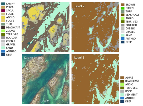
Predicted habitat maps at three levels of detail, based on drone imagery (lower left corner) from Vega. Gundersen et al. 2024
SeaBee Technology
For mapping coastal habitats, we use either rotor drones (for example a DJI M300), which offer increased maneuverability and ability to stand still in the air, or fixed-wing drones (such as a DeltaQuad Evo), which offer longer flight times and can be used for long-distance flights. The drones can be equipped with different types of sensors. Typically, RGB sensors (e.g., SONY RX1RM2 42MP) are used to get an overview of the study area and for annotation, whereas MS sensors (e.g., MicaSense Altum 5band) are used to train the machine learning algorithms. We also have a topobathymetric LiDAR which can be used for detailed mapping of the elevation of both the sea bottom and submerged vegetation, for example for estimating volumes of blue carbon habitats. Depending on fly height, drone images and map outputs are at a spatial resolution of less than 1 cm. All images collected are published at SeaBee’s GeoNode server.
High-quality ground-truth data is crucial for image annotation, training machine learning algorithms, and validating habitat mapping accuracy. Typically, this data is collected in situ using traditional marine habitat mapping methods by experienced field personnel familiar with local species and habitats. A summary of SeaBee’s approach to coastal habitat mapping is given in Kvile et al. 2024.

Kristina Kvile and Hege Gundersen are collecting ground truth data at Runde using the high precision Leica antenna
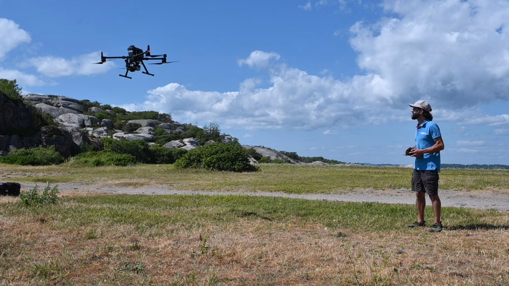
SeaBees drone pilot Meydan Ghareeb (NIVA) with an DJI M210 rotor drone in the air
Contact
Interested in learning more about our work on coastal habitat mapping or opportunities for collaboration? Please contact us:
Lead of water coastal habitat mapping in SeaBee: Kristina Ø Kvile (NIVA).
SeaBee Operations Coordinator: Trygve Heide (NIVA).
Related work
STORIES

PUBLICATIONS