


Welcome to the heart of SeaBee’s journey! Our Stories section takes you behind the scenes of our groundbreaking work, highlighting the people, places, and discoveries that make SeaBee unique. From our adventures in the field to our innovations in drone technology, each story showcases our commitment to better understanding and protecting Norway’s coastal environment. Join us as we share our successes, challenges, and the impact of our efforts towards a sustainable future.

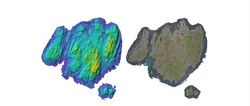
Seeing seagrass in 3D
A new SeaBee study published in Remote Sensing shows, for the first time, how a flying drone carrying a green ...
SeaBee scales up with LUMI
SeaBee partners with Europe's most powerful computer to crack its data bottleneck SeaBee has engaged with the LUMI AI Factory as one ...
World Wetlands Day: SeaBee Helps Illuminate Norway’s Wetlands
World Wetlands Day: SeaBee Helps Illuminate Norway’s Wetlands Along the Norwegian shoreline, wetlands form a quiet but powerful foundation for ...
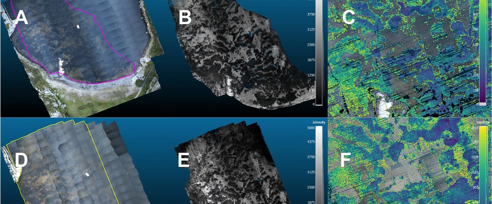
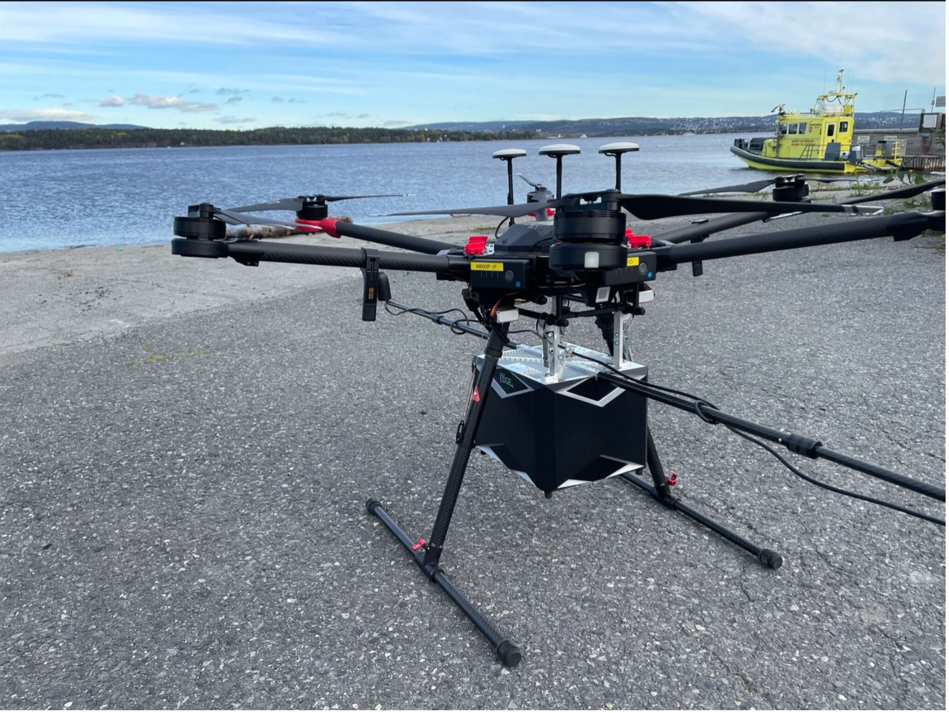
YellowScan Explorer Strengthens SeaBee’s LiDAR Capacity
YellowScan Explorer Strengthens SeaBee’s LiDAR Capacity The YellowScan Explorer is an important part of SeaBee’s remote sensing toolbox. This compact ...
Overview of the SeaBee Data Platform
SeaBee has officially released a comprehensive new report titled "Overview of the SeaBee Data Platform," offering an in-depth look at ...
SeaBee at the MPA in MSP Conference in Bodø
SeaBee Showcases Cutting-Edge Drone and AI Tools for MPA Monitoring at Bodø Conference At this year’s Marine Protected Areas in ...
SeaBee Impact Report
SeaBee has recently completed its "SeaBee Impact Report," showcasing five years of advancements in drone-based coastal research and environmental monitoring ...
SeaBee’s Drone and Sensor Infrastructure report
SeaBee has published a new report titled "SeaBee's Drone and Sensor Infrastructure," providing detailed insights into the advanced technological systems ...
SeaBee Presents Blue Carbon Mapping at ESA Living Planet Symposium
At the 2025 ESA Living Planet Symposium in Vienna, SeaBee contributed to presenting its latest advances in blue carbon habitat ...
Overview of the SeaBee Data Platform
SeaBee has officially released a comprehensive new report titled "Overview of the SeaBee Data Platform," offering an in-depth look at ...
SeaBee Joins Skagerrak Seilasen with Coastal Tech on Deck
This summer, SeaBee took part in the Skagerrak Seilasen aboard the historic full-rigged ship Sørlandet, showcasing drone and autonomous vehicle technology for ...
SeaBee Showcases LiDAR-Based Coastal Carbon Mapping at OBAMA-NEXT Annual Meeting
At the OBAMA-NEXT annual meeting held in Naples on January 28, 2025, SeaBee coordinator Kasper Hancke presented new findings on ...
Interview with James Sample
Interview with James Sample, Senior Engineer, NIVA. Q: What is the SeaBee platform? The SeaBee platform is a cloud-based ...
Interview with SeaBee’s Ragnvald Larsen
INTERVIEW with Ragnvald Larsen, senior advisor at the Norwegian Environment Agency, the executive body of the Ministry of Environment. Q: ...
Interview with Terje Thorsnes
Interview with Terje Thorsnes, senior geologist at Geological Survey of Norway. I work at the Geological Survey of Norway as ...
Interview with SeaBee’s Malin Bø Nevstad
Interview with Malin Bø Nevstad, NTNU PhD fellowship and marine biologist. Malin Bø Nevstad I use the Seabee research infrastructure ...
SeaBee stakeholder event 2024
Wednesday 13 November 2024, Norwegian Environment Agency, Oslo We have now updated our YouTube channel with our stakeholder seminar series! ...
Coastal Habitat Mapping with UAV Multi-Sensor Data: An Experiment Among DCNN-Based Approaches
With recent abundant availability of high resolution multi-sensor UAV data and rapid development of deep learning models, efficient automatic mapping ...
Announcement: SeaBee stakeholder event
Over the past four and half years, SeaBee has built up an operational drone infrastructure with a wide range of ...
Drone-Based Mapping and Monitoring of the Coast
On the 23rd of September, The Norwegian Water Association hosted an event on drone-based mapping and surveillance of the coast ...
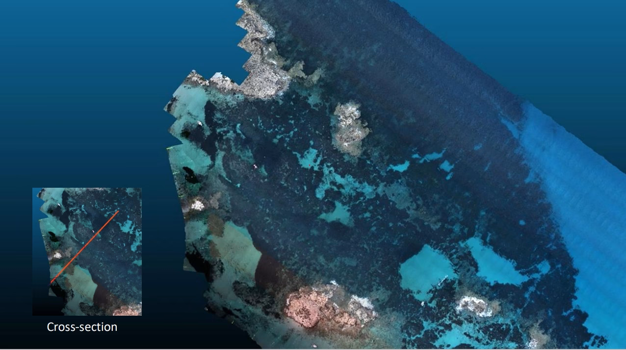
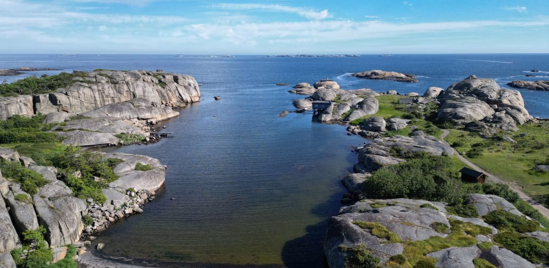
Joint Formentera Drone Mapping Campaign
Take-off with green LIDAR sensors mounted on a drone for high resolution 3D scanning of seagrass meadows at Formentera in ...
Uncovering the Ocean’s Secrets with Drones and 3D Technology
Drones and advanced cameras are powerful tools that help us understand our aquatic environments in ways that were previously impossible ...
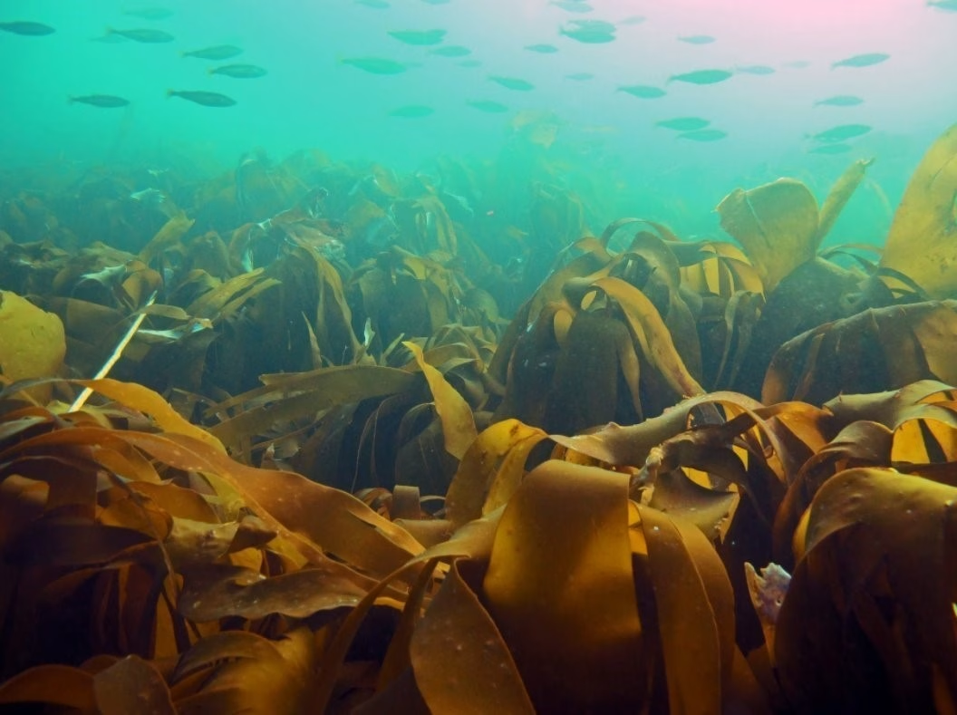
KELPMAP – Upscaling drone-based maps using satellite images shows promise
Helgelandskysten is one of Norway’s most beautiful coastlines, holding World Heritage Status (UNESCO) and ‘Outstanding Universal Value’. It has thousands ...
SeaBee shines at GeoHab 2024
SeaBee Research Infrastructure team members proudly presented at the international GeoHab Conference 2024 (6th – 10th May) in Arendal, Norway ...
SeaBee Out and About
The SeaBee experts have been busy, out and about sharing how SeaBee Research Infrastructure can be used, testing new possibilities ...
New SeaBee Pilots Ready to Fly
Preparations are well underway for the main field season in SeaBee for 2024. SeaBee Research Infrastructure relies on drone-based data ...
Nuts and Bolts of drone technology in SeaBee
The SeaBee Research Infrastructure relies on using state-of-the-art drones and sensors systems to collect data. Anders Gjørwad Hagen (NIVA) is ...
A few favourite things of SeaBee Research Infrastructure
SeaBee Research Infrastructure contains many different pieces that require coordination and expert input to run smoothly and deliver quality data ...
Trained to fly – Drone pilots in SeaBee Research Infrastructure
Drone pilots are a crucial part of the data collection for the SeaBee Research Infrastructure. We sat down with Tor ...
Annual Meeting 2023 – From outcomes to impact
All partners and industry partners met in Bergen for the SeaBee Annual Meeting (25 - 27th October, 2023) to update ...
Increasing flight range and monitoring capacity – Two New EVO Drones added to SeaBee family!
At last, a long-awaited, new arrival has come to SeaBee. SeaBee has received two new EVO drones. The new drones ...
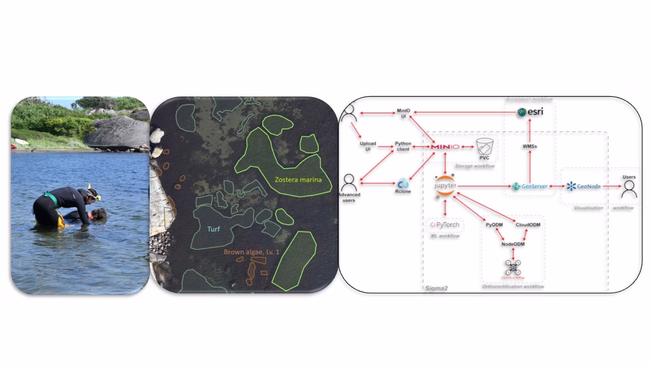
Using drones for mapping seagrass and coastal carbon inventories
SeaBee is being proven in the field through different applications and subprojects. ZosMap is a SeaBee subproject with focus on ...
Two weeks, 440 drone missions, 100 thousand images – The SeaBee Research Infrastructure is taking off!
SeaBee is creating a comprehensive national research infrastructure, enabling sharing and use of data, collected with drones, to better understand ...
SeaBee – The complete package
SeaBee and the Norwegian coast The Norwegian coastline is more than 100,000 km long. The coast is where people live ...
Mapping the Norwegian coast using Artificial Intelligence and drone images
Data Analysis in SeaBee Artificial Intelligence (AI) and machine learning are discussed widely – especially regarding the role as daily ...
Marine ecosystem mapping with drones and photogrammetry
Specialized drone pilots are using drone surveys to research coastal environments with aerial mapping to learn more about these ecosystems ...
SeaBee at GeoHab Conference
SeaBee experts attend this year’s international GeoHab conference (Marine Geological and Biological Habitat Mapping) at Réunion Island. They gave two ...
Sustainable and efficient research support
SeaBee at NIVA Sør´s 40th jubilee NIVA Sør celebrated recently its 40th jubilee. Several SeaBee experts attended, and among them Øyvind ...
Seeing Seals with SeaBee – exploring drone use in counting seals
How many coastal seals are there? Where are they along the coast? Which drone and sensor combinations are suitable for ...
SeaBee Data Platform – Satisfying sense of progress
The data storage and sharing component of the SeaBee infrastructure (the SeaBee Data Platform) is where we design and implement ...
New method using drones to investigate beach deposits
In January, members of the SeaBee team published a scientific article describing new methods on quantification of mass and carbon ...
SeaBee Successfully Tests New DeltaQuad Fixed-Wing Drone, Adding Capacity to the Research Infrastructure
This autumn, the SeaBee team was out on the island of Runde for fieldwork with the aim of improving drone-based ...
SeaBee Supports the Norwegian Environment Agency with Developing Drone-Based Techniques for Kelp Forest Mapping – the KELPMAP-Vega Project
In mid-August, NIVA researchers set out to undertake SeaBee’s first officially funded assignment from the Norwegian Environment Agency: developing techniques ...
SeaBee’s Seabirds Application Presented to School in Bergen for Forskningsdagene
In mid-September, SeaBee team member Sindre Molværsmyr (NINA) gave a presentation on SeaBee’s seabirds application to a class in Bergen ...
SeaBee Team Flocks to Island of Runde for Fieldwork
Greetings from the island of Runde, out on the west coast of Norway! Members of the SeaBee team went out ...
The SeaBee infrastructure supports the Research Council of Norway’s MASSIMAL project
In mid-August , members of the SeaBee team headed to Vega Island, just south of the Arctic Circle, with several ...
The police are investigating egg picking: - Serious
Around 1,200 hooded gull eggs are said to have disappeared from at least 411 nests on Geitholmen in Bærum. The ...
SeaBee Otter in Svalbard
This May, NTNU (Norwegian University of Science and Technology) researchers from AMOS (Centre for Autonomous Marine Operations and Systems) used ...
ISPRS Publication
New paper on coastal habitat mapping and machine learning published, soon to be presented at ISPRS Congress ...
SeaBee’s NIVA team conducts drone workshop at Nesoddtangen
SeaBee’s NIVA team conducts drone workshop at Nesoddtangen ...
Mission Mjøsa
Mission Mjøsa ...
SeaBee drone infrastructure supports research project
Meet “RobOtto”, SeaBee's new surface drone ...
This is how we count seals along the Norwegian coast
Have you wondered how we count harbor seals and sea urchins along the Norwegian coast? One thing is certain: It ...
Nice to Sea you!
Meet “RobOtto”, SeaBee's new surface drone ...
Domo Arigato, Mr. RobOtto
Meet “RobOtto”, SeaBee's new surface drone ...
Out and About
Along a small slice of the Norwegian coastline southeast of Oslo, two members of the SeaBee team ventured out in ...
Mapping the intertidal Zone with Drones
Along a small slice of the Norwegian coastline southeast of Oslo, two members of the SeaBee team ventured out in ...
SeeBee Photo Competition Winner!
Along a small slice of the Norwegian coastline southeast of Oslo, two members of the SeaBee team ventured out in ...
SeaBee: What we do and how it works
An animation video illustrating the Seabee Infrastructure capabilities ...
Making of: SeaBee’s fully remote animation video
Along a small slice of the Norwegian coastline southeast of Oslo, two members of the SeaBee team ventured out in ...
SeaBee YouTube Channel Announcement
Along a small slice of the Norwegian coastline southeast of Oslo, two members of the SeaBee team ventured out in ...
Counting seals using drones – How to explain the science to 9 year old
Martin Biuw recently had the difficult task of explaining his work to a class of nine year-olds, and answering their ...
SeaBee Test Flights Begin Near Danmarkbukta
Along a small slice of the Norwegian coastline southeast of Oslo, two members of the SeaBee team ventured out in ...
First SeaBee Drone Purchase Unboxing
We’ve received a mysterious box… Curious about what’s in it? Medyan Antonsen at NIVA, responsible for instruments and sensors for ...
NIVA bruker droner for å kartlegge og overvåke strandsonen (The Plastic Drone project)
DRONEBASERT MILJØOVERVÅKNING: I fremtiden kan dagens manuelle undersøkelser i strandsonen og på grunt vann med gummistøvler og dykkerdrakt i stor ...
Kasper Hancke Presents Seabee as Part of the CIIMAR Oceanus Seminar Series
The talk is given as an invited contribution to the CIIMAR Oceanus Seminar Series. Acknowledgements to The Research Council of ...
Video Introducing SeaBee is Live
What if we could map and monitor changes along one of the world’s longest coastlines? Introducing the SeaBee project! Produced ...
Droning on about UAVs & Innovative applications
January 18th, 2021 15:00 – 16:00 Many thanks to Carluvy Baptista-Salazar Department of Environmental Science, Stockholm University who kindly mentioned SeaBee ...
Collaboration with REV Ocean
Partnering with SeaBee's project lead NIVA, REV Ocean's vessel will enable NIVA to map new horizons and analyse changes in ...
SeaBee Drone Giveaway Extended
Competition Extended The deadline has been extended to the end of the year!! Recreate the SeaBee logo or name in ...
Detection of MACROplastic on beaches using drones and object- based image analysis
Detection of MACROplastic on beaches using drones and object- based image analysis New Report This pilot study demonstrates UAV-based image ...
First Large SeaBee Drone Arrives at NIVA
The first of the «large» SeaBee drones has arrived at NIVA! This marks an important milestone, placing SeaBee one step ...
Teller steinkobber med helikopterdrone
Steinkobben er vår vanligste kystsel og det finnes trolig rundt 10 000 individer langs norskekysten fra sør til nord. I ...
SeaBee Project Takes Off!
The SeaBee Project’s official kick-off meeting took place from 23 to 25 June at Oscarsborg Fortress in Oslo and virtually, ...